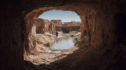
The mounds stretch across the desert in a line so straight it seems impossible without instruments. Each mound marks a vertical shaft. Each shaft connects to a tunnel. The tunnels carry water from the mountains to the oases — underground rivers built by hand a thousand years ago, by people who understood hydrology without knowing the word.
From the air, the khettara system looks like a scar on the landscape. Or perhaps a suture — the stitching that holds life to the desert. The mounds march from the foothills of the Atlas toward the palmeries of Marrakech, Tafilalet, Figuig. They are the visible trace of invisible engineering.
The principle is elegant. At the base of mountains, where snowmelt percolates into aquifers, engineers dug a "mother well" deep enough to tap the water table. From this well, they excavated a gently sloping tunnel toward the settlement that needed water. Gravity did the rest. Water flowed downhill through the tunnel, emerging at the surface kilometres away, filling irrigation channels, fountains, and homes. No pumps. No energy. Just gradient and gravity, which cost nothing and have never broken down.
The construction required brutal labour. Workers descended shafts — some more than 30 metres deep — and excavated horizontally in both directions, working by oil lamp, hauling spoil to the surface in leather buckets. The tunnels were just wide enough for a man to crawl through. Cave-ins were common. The workers, called khettariyyin, were specialists — their skills passed through families. The work was dangerous, respected, and essential. Without it, the oases did not exist. The equation was that simple.
The Marrakech khettara system once supplied the entire city. Over 500 khettaras operated in the Haouz plain. Today, fewer than 20 still flow. Motorised pumps have lowered the water table below the level the tunnels can reach. The technology that sustained a civilisation for a millennium was undermined in a generation — not by a better technology but by a hungrier one. The pumps extract water faster than the aquifer can recharge. The khettaras, which took only what gravity offered, never had that problem. They were designed for sustainability before the word existed.
Some are being restored. UNESCO and local NGOs have rehabilitated sections, recognising that the khettara is not just heritage but infrastructure — a system that works with the water table instead of against it. The mounds still cross the desert. The tunnels are still there, waiting in the dark for the water to return. Whether it will is a question the aquifer has not yet answered.
The khettara mounds south of the Atlas look like scars in the earth. Our guides walk you along them and explain the gravity engineering underneath.
Tell us about your trip →The Facts
- —Khettara mounds stretch in lines across the desert
- —Each mound = vertical shaft connecting to underground tunnel
- —Tunnels carry water from Atlas foothills to oases
- —Persian invention, spread across the arid world
- —"Mother well" taps water table at mountain base
- —Gently sloping tunnel carries water by gravity
- —System built by hand 1,000+ years ago
- —Feeds palmeries of Marrakech, Tafilalet, Figuig
Sources
- Lightfoot, Dale. "Moroccan Khettara." Geoforum, 1996
- Moroccan Agence du Bassin Hydraulique. Groundwater and aquifer data
- Mezzine, Larbi. Le Tafilalt. Faculté des Lettres, Rabat, 1987
Practical questions