There was nothing here.
In 1070, the Haouz plain south of the Atlas Mountains was scrubland. Red earth. Scattered palms along the Tensift River. No settlement, no fortress, no market. The nearest town of any significance was Aghmat, 30 kilometers south in the foothills — a prosperous trading post, but hemmed in by mountains and impossible to defend from multiple directions.
Yusuf ibn Tashfin looked at the empty plain and chose it.
He was 64 years old, or possibly older — the sources disagree on his birth year. A Sanhaja Berber from the deep Sahara, he had spent his life in sand, not cities. He didn't read. He spoke Berber, not Arabic. He wore wool, not silk. He ate barley and camel meat. The chroniclers describe him as lean, dark, soft-spoken, with a scar above his left eye from a Zenata spear.
This man built Marrakech.
The site made military sense. The plain was open — cavalry country, and the Almoravids were cavalry. The Atlas Mountains formed a natural wall to the south. The Tensift provided water. And the location sat at the junction of every road that mattered: the caravan routes from the Sahara, the paths through the Atlas passes, the road north to Fes and the Mediterranean.
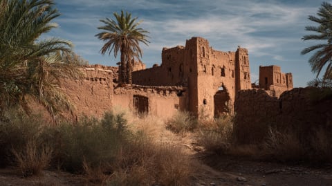
Construction began with a qasr — a fortified compound of rammed earth, the same red pisé that would give the city its color for the next thousand years. The earth came from the plain itself. Mixed with lime and straw, pounded between wooden forms, left to bake in the sun. The walls rose the color of the ground they stood on. That is why Marrakech is red.
The first mosque went up in the 1070s. Not the Koutoubia — that was Almohad, a century later. This was a simpler structure, a communal anchor for the military camp that was slowly becoming a city. Around it, the first souks formed. Merchants relocated from Aghmat. Artisans followed. The Saharan caravans, which had previously stopped at Aghmat or Sijilmasa, now came directly to Marrakech.
Then the water. The Haouz plain was fertile but dry. Yusuf's engineers built khettaras — underground channels, some stretching 20 kilometers, that tapped the water table at the foot of the Atlas and carried it by gravity to the city. The system was ancient — Persians had invented it, and it had spread across the arid world — but the scale at Marrakech was extraordinary. Hundreds of khettaras, feeding gardens, fountains, public baths, and the palm grove that still stands on the city's eastern edge. The Palmeraie — over 100,000 trees — exists because of infrastructure that Yusuf ibn Tashfin laid in the 1070s.
From Marrakech, he conquered everything. Fes fell in 1075. The Rif by 1080. Western Algeria by 1082. Ceuta in 1083. Then Spain called. The taifa kings, losing ground to Alfonso VI of Castile, sent word across the strait. Yusuf crossed in 1086 and crushed Alfonso's army at Sagrajas.
He kept going. By the time he died in 1106, at roughly 100 years old, his empire stretched from the Senegal River to Zaragoza. The largest Berber empire in history. All of it administered from the red-walled city on the plain.
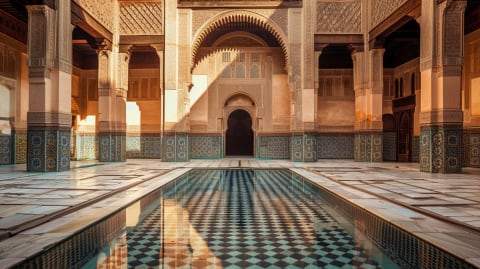
His son Ali ibn Yusuf expanded the city further — adding proper ramparts (19 kilometers of walls, still standing), extending the khettara network, commissioning the first grand mosque. Ali also invited Andalusian architects from Cordoba and Seville, and their geometric precision fused with the Saharan austerity that Yusuf had brought from the desert. That fusion — Saharan simplicity meets Andalusian refinement — became the architectural DNA of Marrakech.
The name itself may come from the Amazigh "amur n akuch" — Land of God. Or "mur akush" — pass quickly, a warning to travelers. The Europeans couldn't pronounce it properly. They wrote it as "Morocco." The city gave the country its name.
His mausoleum is still in Marrakech. Most visitors don't know it exists. A simple crenelated structure on Rue Sidi Mimoun, across the avenue from the Koutoubia, maybe 200 meters from Jemaa el-Fna. No signs. No tour groups. The French found it in the early 20th century — aerial photographs revealed a walled quarter in the center of the city with no visible entrance. They broke through the wall and found the tomb of the man who built the city.
Twelve million tourists a year pass the Koutoubia. Almost none cross the road.
A man from the Sahara who couldn't read, who ate barley and wore wool, who chose an empty plain because the ground was flat and the water was underground.
The earth is still red.
The earth is still red. Three days in the city that Yusuf ibn Tashfin built from nothing on a plain at the foot of the Atlas.
Tell us about your trip →The Facts
- —Founded ~1070 by Yusuf ibn Tashfin on the Haouz plain
- —Red pise walls made from local earth — why Marrakech is red
- —First mosque built 1070s (not the Koutoubia — that was Almohad, ~1150)
- —Khettara underground channels up to 20km long
- —Palmeraie: 100,000+ palm trees, fed by original Almoravid water system
- —Ali ibn Yusuf added 19km of ramparts (still standing)
- —Fes conquered 1075, Spain 1086
- —Empire: Senegal to Zaragoza
- —Yusuf died ~1106, possibly 100 years old
- —Mausoleum on Rue Sidi Mimoun, 200m from Jemaa el-Fna — found by French via aerial photography
- —"Marrakech" may derive from Amazigh "amur n akuch" (Land of God)
- —Europeans wrote it as "Morocco" — city gave the country its name
- —12 million tourists per year today
Sources
- Deverdun, Gaston. Marrakech: des origines à 1912. 1959
- Wilbaux, Quentin. La médina de Marrakech. L'Harmattan, 2001
- Terrasse, Henri. Histoire du Maroc. Atlantides, 1949
Practical questions